Stone Wall or Hedgerow: Reading a County Boundary
Stone wall or hedgerow clues reveal how a county boundary was divided, maintained and absorbed into the landscape; learn what to look for on a walk.
The common mistake when reading a county boundary is to treat its present appearance as a label: stone means one kind of land, hedge another. That shortcut can obscure the real clues—how the boundary was built, repaired and allowed to change—and leave a walker with a tidy story that the landscape does not support. A stone wall or hedgerow is better read as a working edge, with marks left by both people and weather.
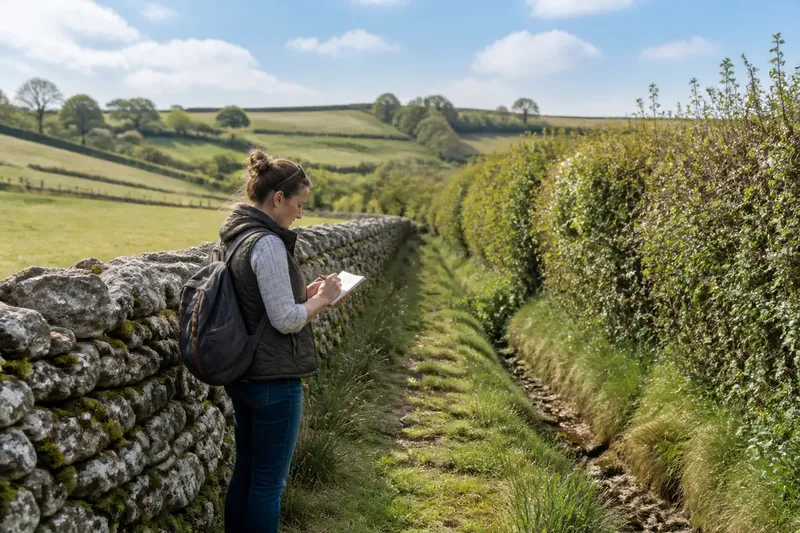
Imagine a hypothetical walk along a lane between two invented parishes, Aldercombe and Brackenford. A low stone wall runs beside one stretch, then gives way to a thick hedgerow, with a shallow ditch appearing and disappearing between them. The aim is not to decide which boundary is older at a glance, but to build a careful account from what can actually be seen.
Start with the line
Before inspecting the material, follow the boundary’s course. Does it run straight across an open slope, bend around a hollow, or trace the edge of a stream? Does it meet a lane at a right angle, or turn to join another boundary? The line may tell you more about the division of land than the wall or hedge alone.
On the imagined walk, the wall makes a long, fairly direct run across a slope. The hedge follows a softer curve around a wet hollow. Those contrasts invite questions, not conclusions. A straight line might reflect a deliberate division, but a later boundary could also be straight; a bend may follow difficult ground, an older field edge, or a feature now hidden by vegetation.
Look for junctions. A boundary that continues through a junction without a visible break may belong to a different phase from one that stops against another feature. Changes in direction, slight overlaps and short lengths of abandoned bank can all help you sketch a sequence. Keep the sketch simple: record what joins what, and mark uncertainties rather than filling gaps with a story.
Reading a stone wall
A dry-stone wall is assembled from stones without mortar, often with larger facing stones and smaller material packed within. Its profile can show how it has been cared for. A reasonably even top and a coherent face suggest continued attention; a leaning section, loose stones or a gap may point to repair needs, disturbance or long neglect. None of those signs gives a date by itself.
Notice the stones as well as the shape. Their size, colour and roughness may resemble nearby bedrock or may differ from it. A wall built from locally available stone can sit naturally in the ground, while a change in stone type along its length may hint at a repaired section or a shift in materials. A broken wall might also have been patched with whatever was to hand.
Its practical role matters, too. A wall can mark ownership, separate fields, contain livestock or serve more than one purpose. Look for a gateway, a blocked opening, a change in height or a place where the wall narrows. These details can suggest how people and animals moved across the land, though the original use may no longer be visible.
At Aldercombe’s wall, the imagined walker notes a neat stretch near the lane and a rougher, partly fallen section farther up the slope. The difference may reflect access to materials or labour, or simply different repair histories. The useful observation is that the wall’s condition varies; choosing one explanation would go beyond the evidence.
Reading a hedgerow
A hedgerow is not just a row of shrubs. It may include a raised bank, a ditch, mature trees, younger growth and gaps where the original plants have changed. Look along its length for a continuous base and a consistent line. A hedge planted on a bank can define an edge as clearly as stone, while a ditch may mark the side from which soil was moved.
Species and structure provide clues about management. A dense, regularly cut face suggests trimming; a broad, irregular top may reflect less frequent cutting or a different approach to keeping the hedge. The presence of mature trees among shrubs can indicate that the boundary has been allowed to grow up, but trees may also have been deliberately retained. A single plant should not be treated as a calendar.
Check whether the hedge is continuous or interrupted by gates, tracks and breaks. A gap can result from a lost entrance, later access, storm damage or routine work. The surrounding ground helps narrow the possibilities: worn tracks, a paired gateway or a clear approach may indicate regular passage, whereas a ragged opening with no path tells less.
On the hypothetical walk, the hedge curves around the hollow and stands on a low bank. A ditch is visible on one side for part of the way, then fades beneath grass. The walker records those features separately instead of calling the whole thing simply “an old hedge”. That description preserves the evidence: hedge, bank, partial ditch, changing course.
What does each boundary reveal?
Does a stone wall mean the division is older?
Not on its own. Stone walls can be built, rebuilt or moved, and hedges can persist for a long time while their plants are replaced. Compare the boundary’s alignment, junctions and construction with nearby features before suggesting a sequence.
What can a ditch beside a hedge tell you?
A ditch may relate to the making or upkeep of the boundary, drainage, or the management of stock and access. Note its position, depth in broad terms, continuity and relationship to the bank, but avoid assigning a single purpose without supporting clues.
Why might a boundary change from wall to hedge?
The change could reflect different ground, available materials, changing maintenance or a later alteration to the division. Look closely at the join: a clear stop, overlap or surviving bank may show how the features meet, while an obscured transition leaves the sequence uncertain.
How should I record what I see?
Write down the route, materials, visible repairs, openings, banks, ditches and connections, then separate observation from interpretation. A quick sketch or map annotation can preserve the order of features and help you revisit questions without turning guesses into facts.
Build a cautious account
For the invented Aldercombe–Brackenford walk, the observations now form a modest account. The wall runs fairly straight over the slope, varies in condition and has a gateway near the lane. The hedge bends around wetter ground, stands on a bank and has a partly visible ditch. The landscape offers a contrast in construction and setting, but not a firm date or a single explanation for the change.
Say the walker first assumes that the hedge replaced the wall. On a closer look, the two lines do not meet: the wall ends beside a track, while the hedge begins beyond the hollow and follows a different curve. The expected result of checking the junction is not a definitive timeline, but a better distinction between what is connected and what merely appears nearby. The initial theory becomes less certain, and the notes become more useful.
That is the central lesson of reading a boundary: treat it as evidence with layers, not as a caption for the landscape. A wall’s fallen stones may speak of repair; a hedge’s bank and ditch may show earth moved as well as plants grown. Their route, joins and interruptions can tell a richer story than their material alone.
What not to pursue
It is not worth trying to identify every shrub, or assigning an exact age to a wall from one attractive stone. Nor does a boundary need to be forced into a single origin story. A few clear notes about its form and connections are more dependable than an elaborate explanation built on one clue.
For a stone wall or hedgerow, the most revealing question is often not which one came first, but what each has had to do in this particular place. Follow the line to its joins, notice where maintenance changes, and let the gaps in the evidence remain visible. That approach leaves you with a grounded reading of the county landscape—and better questions for the next bend in the boundary.