Why Market Streets Often Meet at the Oldest Crossing
Why market streets often meet at an old crossing: read the junction’s clues to understand trade routes without mistaking a street pattern for a town’s origin.
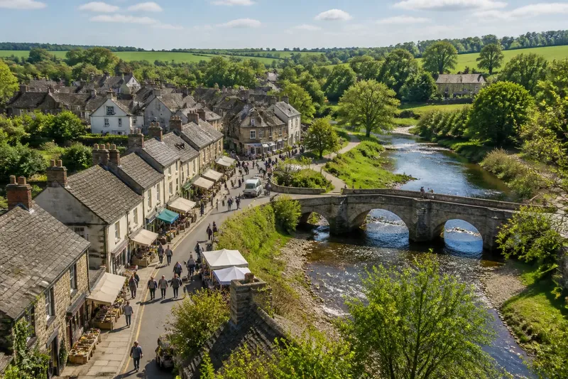
The common mistake is to treat a market street that converges on a bridge or ford as proof that the town began there. That neat story can hide the cost of later changes: a bridge may have replaced a ford, a market may have shifted, and a road may have been rerouted long after settlement began. Why market streets often meet at an old crossing is a question of accumulated movement, not a single founding moment.
A crossing gathers journeys into a narrow point. Traders, carriers and local residents approaching from different directions have reason to pass through it, while an established route offers a natural place for exchange. Over time, shops and stalls may line the road leading to the crossing, turning a passage into a commercial street. Yet the visible pattern is a clue to how a place worked, not a complete record of how it came into being.
Routes draw people together
Before a permanent bridge, a river might be crossed at a shallow ford, by ferry, or at a landing where a boat could be reached. The practical crossing depended on the river’s depth and current, the banks’ shape, and the roads that brought people there. A track could converge on that point because it was easier to cross there than elsewhere, even if the surrounding land was already occupied.
Crossings concentrate traffic, but they do not create every route from nothing. A road from a nearby village might follow an older ridge or dry ground, then turn towards the river. Another route could link farms, a religious house, a port or a larger market town. Where these paths meet, movement becomes visible as a junction; the reasons for each path may be different.
Repeated journeys give a route a kind of practical authority. Travellers favour a familiar approach, carriers need access for goods, and people selling provisions benefit from being near passing traffic. A market can grow beside this stream of movement, with activity spreading along the approach road rather than appearing as a tidy square.
Markets follow the approach
A market street often works as an elongated place of exchange. Buildings fronting the road provide shelter, storage or room to sell, while the open carriageway allows people and goods to keep moving. The arrangement can look like a deliberate plan, but it may also reflect gradual additions to a route that already mattered.
The crossing and the market need not have appeared together. A ford may have drawn traffic before there was a regular market. Conversely, trade might have developed for reasons beyond the river: a local estate, a cluster of crafts, or links with a wider road network could support exchange. The crossing can help explain why a street became busy without explaining why a settlement first took root.
Consider an invented situation: a small settlement stands on dry ground above a river, while a ford lies along its edge. Carriers begin using a road through the settlement to reach the ford, and sellers gather along that approach; the expected visible result is a busier, elongated street pointing towards the river, even though the settlement itself may pre-date the trade route.
Bridges alter the evidence
A permanent bridge can draw traffic towards a crossing, but it can also change where people approach the river. Its landing may sit beside, rather than directly over, the older ford. A rebuilt bridge may align with a straighter road, while an earlier track survives as a narrow lane or a kink in the street. On a modern map, these layers can appear to be one simple arrangement.
Bridges also make movement more dependable in some conditions, encouraging heavier or more frequent traffic. Shops may follow the most convenient approach, and older riverside paths may lose their role. Later road engineering can widen, straighten or divert the route again, leaving a market street aimed at a crossing that no longer carries the same traffic.
A modern road junction is therefore not a frozen snapshot of an early town. It shows the route system as altered by repairs, property boundaries, river works and changing transport. A bridge’s apparent centrality may be recent even when a crossing has long mattered nearby.
Reading the street pattern?
Does a market street prove the town began at a crossing?
No. It suggests that movement and trade became connected there, but a settlement may have existed before the market street took shape. Treat the street as evidence of use and growth, not as a founding certificate.
How can an old crossing be recognised?
Look for a bridge, ford name, former ferry landing, or tracks and lanes converging on a river reach that appears easy to cross. These clues can point towards a long-used route, but no single feature establishes its age or original form.
Why does the street point at a bridge built later?
A newer bridge may have replaced a ford or ferry close by, preserving the general direction of travel. Roads may also have been redirected to reach a more convenient bridge landing, so alignment alone cannot date either the crossing or the street.
What evidence helps explain the pattern?
Compare historic maps with the present street plan, then look for old route lines, river changes, market references and surviving buildings along the approach. Local archives, map collections and planning records can add context; where a site’s age or status matters, consult a suitably qualified local heritage professional.
Clues need company
Map comparison is useful because it reveals what has shifted. An older map may show a road bending towards a ford where the current road runs to a bridge, or a market street extending beyond its present commercial centre. Map dates and coverage vary, so compare features rather than assuming each map records the same level of detail.
Buildings can add another layer. A row of older plots or shop fronts along an approach may indicate prolonged activity, while a broad gap might reflect a later road cut or a lost market space. Neither appearance gives a date by itself; building fabric and plot shape need to be read alongside maps and local records.
Riverbanks are not fixed either. Flooding, erosion, drainage and deliberate engineering can shift the usable crossing or obscure an earlier landing. A present-day walk can help identify slopes, narrow approaches and remnants of old routes, but the ground’s current shape should not be mistaken for an unchanged landscape.
What is not worth the effort is forcing every bend or oddly placed building into one tidy origin story. A crooked street may result from several practical adjustments, and a straight one may be the product of later improvement. The more persuasive account is often the one that allows different parts of the pattern to have different histories.
What the junction can say
A crossing-centred street pattern can tell you that routes, exchange and access became closely entangled. It may show where travellers entered, where sellers could reach them, and how the built-up area extended along a useful line. Those are meaningful clues about a settlement’s working life, even when its beginnings remain uncertain.
To read why market streets often meet at the oldest crossing, start with the route’s practical logic, then compare it with the river, bridge, maps and buildings. Ask what each piece can establish and what it cannot. A junction becomes more revealing when treated not as a town’s single origin, but as a place where many journeys—and many layers of change—converged.